Pages

Thursday, June 30, 2011

Grand Teton: 5 hrs 17 min

Jason Dorais, Andy Dorais, and I went back to the Grand for a speed attempt.  We got it done in 5 hrs and 17 minutes.  I'd like to write something that expresses what went into this project, how I feel about it, and why.  I hope to get to that someday soon.  For now, here are a few links to some reports on the trip and the "proj":


Sunday, June 19, 2011

Lone Peak: Up Big Willow, NE Couloir, Down Bells

NE Face of Lone Peak, January 2011
I see Lone Peak almost everyday.  From my car and my work at window, it often holds my attention.  What's it doing today?  While it is situated quite closely to the valley, the approach is long by Wasatch standards--you can't drive to its base and start climbing.  And that's one of the characteristics that makes it my one of my favorites.

Friday night, when Lone became the target, good partners were hard to come by.  The Dorais bros were running RAGNAR, Brother Sam had to work, Bart is still out of commission.  So it became a solo mission.  My plan was to drop a bike at the Bell's Canyon trailhead, climb up from the Big Willow trailhead, ski the NE Couloir, ski out Bells Canyon, and ride my bike back to the Big Willow trailhead. 

I've heard different things about Big Willow as a way to get up Lone Peak.  If you look at it from the valley, it is a very direct way to go.  More direct than Bells or Dry Creek (which departs from Alpine).  Fritzrips says Big Willow the way to go.  But I've heard horror stories about Big Willow too, all of which involve epic bushwhacks.  I've never been up Big Willow and approached it with a bit of trepidation.  I figured that at worst I'd get an early morning hike in.  Luckily, my inner homing pigeon was functioning, and after a couple hours, much travail with caterpillars and their silky wisps, I was at the head of Big Willow cirque.  For those who might try Lone Peak via Big Willow, I'll give you a hint: the Sawmill Trail.

My Dynafit boots, MontBell puffy, CAMP nanotech crampons, ski crampons, and a bottle of water fit nicely in my 30L pack.  Besides a few gels, a headlamp, Whippets, and skis that's pretty much all I carried.  From 5500 ft where the trail starts, I fast hiked and sometimes jogged up the trail.  By 9000 feet, I was in the cirque and walking on hard snow.  Travelling conditions were prime, so I kept my running shoes on until the cirque steepened, at which point I switched to my boots, race skis, and ski crampons.  

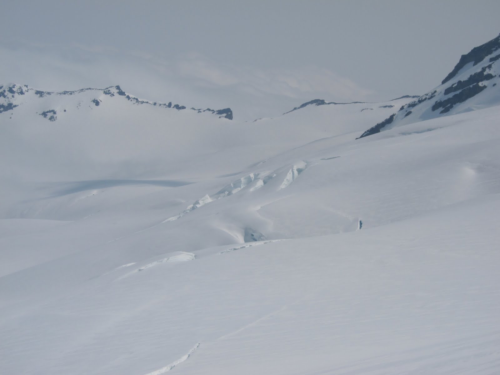
Big Willow Cirque, June 2011
The other side of the "Notch."
Near the top of the cirque, I gained a ridge, mostly hard snow and a few granite blocks.  I tried to put my crampons on, but realized that they were set to fit a different pair of boots, and didn't fit the ones I had on.  Without tools to fix them, I went without crampons.  (In hindsight, I guess a mini Leatherman doesn't weigh that much.  Maybe I'll carry one from now on.)  Going crampon-less made the the final ascent and traverse to the summit a bit more adventuresome.  

Traverse to the top of Lone Peak.
I topped out on the North Summit in 2 hours and 59 minutes.  And promptly texted this photo to my buddies.


As I was climbing the cirque, I was thrilled that the snow was hard.  But I worried that I was too early for the corn cycle.  As it turned out, the NE face of Lone Peak corns up about 8:00 a.m., which is about the time I skied it.  


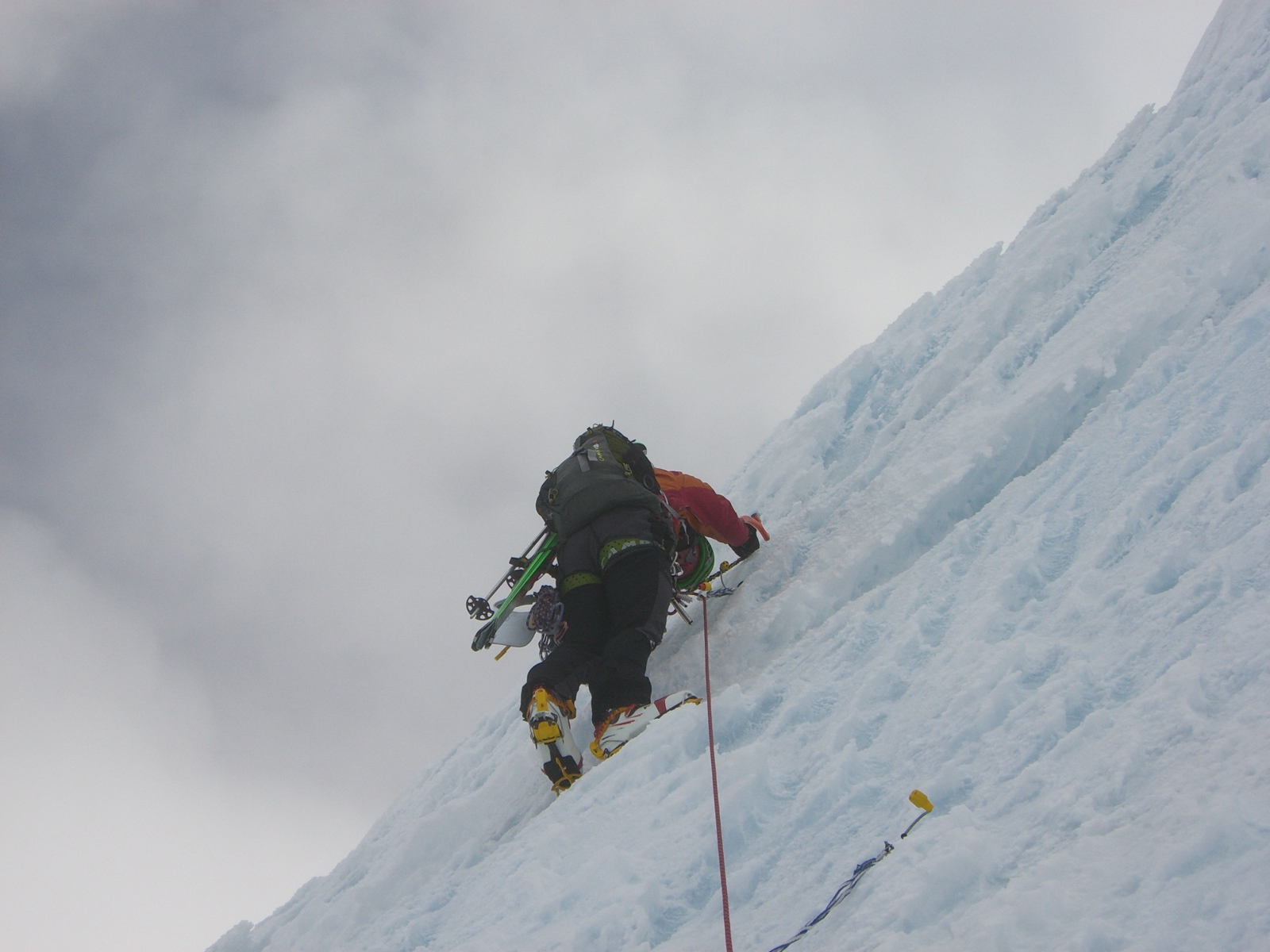
As I made turns off the headwall of the NE Couloir, I thought I'd hit the jackpot.  But soon I found myself dodging runnels.  Because of a very deep (like 6 feet) runnel, midway down the chute, I had to ski a contrived line, and eventually had to downclimb into the runnel and then climb out of the runnel to continue my contrived line.

The chute within the chute.
As I neared the bottom of the NE Couloir, I was relieved to discover that the cliff was still sufficiently filled in. While there was a large glide crack--huckable if you were crazy enough--between the cliff and the snow, the crack was skirtable.  As I reached the apron, I breathed a sigh of relief, and arced my turns a bit bigger.  Then, I skied a couple thousand feet of corn, out Bells Canyon.

Eventually though, I ran out of snow.  I think I startled several scouts and families as I ran down and out the Bells Canyon trail with skis on my back, wearing a weird grin on my face.  That didn't deter me much because I was hoping to keep my car-to-car time under 5 hours.  But the inner homing pigeon must have died because at Bells reservoir, I got turned around.  Weird, I know but it happened.  At the exit, my bike was waiting for me.
Bells Canyon.  I started running up this road before I realized I ought to be running down this road.

My waiting bike.  DON'T LAUGH AT MY RIDE!  Yes, it is a women's styled bike.
And yes, I can sit perfectly upright on this bike -- perfect with a ski pack on.
 After a leisurely cruise down Wasatch Blvd, I made it back to my car.  I clocked in at about 5:11 car-to-car.  At the trailhead, I met Chris Cawley who had made an attempt on the Grand Teton earlier this week and was out for a trail run.  He laughed at my ride too.

Mode of Travel: Ski, Run, Bike
Stats:  5:11
Miles: 14.9
Vert: 6528

Monday, June 13, 2011

Spring Wackiness

6.13.11 -- The Pfeif

Obligatory Ridge Shot
Pfeifferhorn
I've not yet given up on skiing. I think I'll be doing that until at least July, which means that I'm going to be a really crappy runner this year. Oh well. . .

This morning (on June 13th!) before work, Billy Demong and I skied from the White Pine TH to the top of the Pfeif, traversed out of Maybird and skied a shot into Red Pine, climbed Lake Peak, and skied a shot into White Pine, and then skied out.  We started out in trail shoes, but very quickly, we realized that we could pretty much skin from the car, and changed into our ski boots.  For those interested, coverage up high is very good.  Skiing is variable, but generally good early in the morning and especially up high.  We were skinning by 5:30 and done by 10:00 am.

Billy chatting with a sponsor on his way up:  "yeah, just out for a little training this morning. . . on the Pfeif."

Shot into Red Pine
Pfieff, Hogum, and Lightning Ridge in the background.  I think I found Snap Dragon!  Finally.

6.11.11 -- San Rafael aka Little Grand Canyon Canoe Trip

On Saturday, I got to spend some time with my family on the San Rafael River.  It's a seasonal river that is floatable at 300 cfs.  On Saturday, it was pushing 1000 cfs.  We had one close call when my dad and his canoe and got swept under a big cottonwood tree that had fallen across the river.  Floating through the 17 mile stretch without having to expend a whole lot of energy was welcome.

Ethan (my son) enjoying the San Rafael.
6.8.11 -- Olympus West Slabs (Up this Time)


On Wednesday morning before work, Jon Schofield, Tom Diegel,  Jason Dorais and I did our attempt at a fast and furious "run" up the West Slabs.  Having "skied" it a month or two ago, and inspired by Jared Campbell's 1:01 car-to-car time (wow!), I was anxious to give it a shot.  I figured if we could "ski" a 5.6 rock climb, we ought to be able to solo it.  Good logic right?  Our time was nowhere near Jared's, and the glissade down the Apollo Couloir was almost scarier than skiing the West Slabs.  But it was a success and something I might incorporate into my routine this summer.  Here are a couple video links that document some of the shenanigans that occurred:  (a) Jon descending Apollo in style, and (b) Jon's good friends, courtesy of Jason Dorais.


Me and Tom climbing.  Tilt was intentional.  Photo: Jason Dorais

Sunday, June 5, 2011

Grand Teton

On Saturday, I skied the Grand Teton. I've been after this all year, and I'm happy that it's done . . . for now.

Grand Teton with the Ford, Chevy, and Stettner Couloirs visible. 
Just having returned from a trip to Baker and with some mandatory family stuff on Saturday afternoon, I wasn't intending on doing much this weekend.  But when I found out Brian Harder, Jason Dorais, and Brother Sam had something brewing in the Tetons, I couldn't stay away.  Initially, I resisted and told them I was out.  But by Friday morning, I had succumbed to the Teton gravitational pull.  My plan: get to Jackson late on Friday, sleep a couple hours, start with Brian, Jason, and Sam at 2 am, climb and ski the Grand, and then be back in Salt Lake by 4 pm on Saturday.

We set out to climb the Grand in our style: fast and light.  We wore tight clothing, some iteration of Dynafit's TLT boot, and no ski was wider than 75 mm.  Luckily, the conditions suited that style.  The skies were clear and at Lupine Meadows, the snow patches were hard and frozen.  The splits were roughly as follows:  Meadows at 1:50, top of Teepee Col at 3:__, top of the Grand at 5:15, bottom of the Stettner at 6:12, Meadows at 6:35, lost at 6300 ft at 6:59, Lupine Meadows TH at 7:21.

With ski crampons, I kept my skis on until the top of the Teepee Col.  From there, we switched to crampons and ice tools. The conditions in the Stettner, Chevy, and Ford were mostly breakable crust above top-of-boot to knee-deep snow.  Spindrift poured over and through us in the Stettner.  There were two small ice bulges in the Chevy.  The snow in the Ford was softer and deeper.  We all simul-soloed--climbed and descended without ropes.

At the bottom of the Stettner, I left my partners who were on a much bigger mission (Grand, Middle, and South linkup).

While I'm happy with the time of 7:21, I think that it could be done in closer to 6 hours. . . . something to dream about.

My favorite photos of the day:

Jason Dorais and Brian Harder climbing Tepee Col
First light on ??

Sam in the Stettner Couloir

The crew in the Chevy Couloir


Headwall of the Ford and nearing the top of the Grand Teton with the Tetons at our feet.


Sam, 30 feet from the summit.

Jason Dorais skiing off the summit of the Grand Teton.

Thursday, June 2, 2011

Mt. Baker: Up the North Ridge, Down the CD Route

Mt. Baker
On Memorial Day, Brother Aaron and I set out to climb and ski Mt. Baker.  We woke up to rain.  We drove up Glacier Creek road in the rain, and when we hit snow about 2 miles from the trailhead at about 3000 feet, we started hiking and then skinning . . . in the rain.  Although we dared not discuss it, the question that filled our minds was, "why are we climbing a volcano, blind, in the rain?"  But we only had one day, and we climbed with a hope and a prayer that the skies would clear.  And guess what?  By the time we hit 7000 feet, the clouds and mist began to lift!  For a while anyway.

Our first glimpse at Baker's North Ridge
North Ridge beginning to reveal itself.
Top of the Coleman Glacier
 As the skies cleared, we could see that we were just above the Coleman Glacier with its bergschrund (I've always wanted to be able to use that word, yessss.) less than 100 yards below us.  Getting to the North Ridge requires a crossing of sorts across the Coleman Glacier.  Toward s the top of the glacier, it seemed pretty filled in.  Even so, because what lay beneath was a bit unnerving, Aaron and I roped up and did our best to be safe.  Aaron boot belayed me over this crevasse.


As we crossed, clouds rolled in and out, sometimes killing our visibility.  I couldn't shake that nagging concern of whether we should pull the plug.  But the drive to get on the North Ridge and the fear of re-crossing the glacier in low/no vis conditions prevailed.

The north face of Baker was impressive.  The lower face was littered with ice fall debris, and higher hung huge seracs.  I'd heard that the Coleman Headwall, which is on Baker's north face, was a worthy ski descent, but from where we were, it looked more than daunting.

Once across the Coleman Glacier, we front pointed up about 1000 feet of 60 degree hard snow, and soon the notorious "ice cliff" came into view.  I wondered whether we ought to approach via climber's right or left, and eventually opted for left.

Ice cliff on the North Ridge of Baker
Climbing the ice cliff was really cool.  The ice was blue and very hard and brittle.  I was glad that I had some vertical point crampons.  We had 8 ice screws and each of us had 2 tools.  We climbed on one 8.2 mm half rope.  Aaron dodged dinner plates, and I climbed first.  The first 20 meters or so up the cliff were the and once over the cliff, the pitch mellowed out.  The first pitch measured 59.8 meters.  As we climbed, the clouds rolled in again, and the low/no vis significantly bumped up the adventure rating.

Climbing the ice cliff
Aaron above the ice cliff  


Pitch 2: Take!!!
Once above the ice obstacles, between us and the summit was another long pitch of steep hard snow.  To the left and right of us were large hanging seracs.  Soon, the clouds lifted and we could see the summit above us; below us, we had a great view of the Roosevelt and Coleman Glaciers.  As we neared the top, we were blasted with a cold wind.  Aaron was happy.


Fortunately for us, there were ski tracks down the Coleman-Deming route, which we followed.  The descent was relatively casual.  And lucky for us, the exit was perfect.  We were able to descend a solid 7,600 feet without having to hike, skin, or pole.

Aaron skiing off Mt. Baker on the Coleman-Deming route.
Stats:

Gear: Dynafit Broad Peak Skis, La Sportiva RT Bindings, Dynafit DyNA boots, Grivel G22 crampons, Cassin X-Mtn Tools, 8 Grivel screws, 1 8.2mm Edelweiss rope, CAMP packs, BD Whippets.

Time: 11 hrs 32 minutes car to car.

Vertical:  8500 feet

Wednesday, June 1, 2011

Ski to Sea

Memorial Day weekend 2011 will be memorable. I raced in the Ski to Sea race and I climbed and skied Mt. Baker. First, the Ski to Sea.

S2S is an adventure relay race that starts at Mt. Baker ski resort and finishes in Bellingham Bay, Washington. It travels 100 miles and includes the following legs: XC ski, alpine ski, run, road bike, canoe, mountain bike, and sea kayak. My teammates for this event were pulled together by Billy D and a Bellingham local who had some interest in bidding for the win. In other words, I had the privilege of racing with some accomplished athletes. Our team was called "Tony's Demons" and included Taylor Fletcher (XC Ski), Me (Alpine Ski), BJ Christenson (Run), Sam Krieg (Road Bike), Trevor Robinson and Ivan English (Canoe), Mitchell Peterson (Mountain Bike), and Andrew McEwan (Sea Kayak).

Tony's Demons raced strong throughout the race. Of the 500 or so teams that entered, Tony's Demons finished 4th overall with a time of 6 hours and 27 minutes.  Barron's Heating won the contest and finished in 6 hours and 11 minutes. Team Barrons is apparently a fixture in the S2S and has won multiple times. Because all of Tony's Demons are competitive (maybe to a fault), most of us were slightly disappointed at our placing.  That said, we were very happy with the way our individual legs went and feel like our efforts were good.  As the dark horse, it was fun giving the favorites a legitimate run.

My leg involved a short downhill ski, a ~1000 foot booter, and a fast groomed descent.  It was sandwiched between the XC ski and the run.  Given the relative shortness of the leg, I was surprised when Max Taam, Brandon French, Chris Kroger, and Greg Ruckman--all members of the 2011 US Skimo Team toed the line. Apparently, Bellingham is serious about the S2S.  Ruckman ran the race sans poles and decimated the course record, finishing in 17:58, and earning the "Top Gun" award.    Max (18:17) broke his ski.  Brandon (19:30) was wearing shorts.  I finished in 19:33 with my lungs and legs on fire.  As always, it was fun racing with those guys.

And a big thanks to Tony's Demons.

Full results can be viewed here.

Here are a few pictures taken by Brother Aaron:

XC Leg Start

BJ Christenson at the Run Leg Start about to run 8 miles
in 37:25!

L to R: BJ Christenson (Runner), A. McEwan (Kayaker)
T. Robinson (Canoe), Me (Alpine Ski),
T. Fletcher (XC Ski), I. English (Canoe)
A. McEwan finishing -- he brought our team from 6th place
to 4th place during his leg